Saturday, January 5, 2008
Tongariro Alpine Crossing
On Thursday 3rd January 2008 we walked the Tongariro Alpine Crossing based at National Park. We were dropped off by the 'Howards Lodge' bus along with 25 other tourists at 8 am at Mangatepopo and started our morning walking into the sun. The volcanic plateau comprises two massive volcanoes: Ruapehu (2797m) and Tongariro (1967m) — the young, symmetrical cone of Ngauruhoe (2287m) is considered to be a vent of the Tongariro Volcano. The Tongariro Crossing explores the Tongariro-Ngauruhoe complex. This rugged alpine trek is exposed and climbs to 1900m. It is a 17 k walk taking between 7- 9 hours. We completed it, intact and still fresh (or almost) in 7 hours interspered with 4 breaks for a snack and drinks. Mostly, it is not too arduous although one section is quite strenuous. Near the beginning, a 45-minute hand-over-hand climb over raw, black basalt is decribed as having most trekers sweating and pausing for breath.

Looking up along the initially wide and smooth track that rises gently up the tussock valley there is the cone of Ngauruhoe in the distance. Beyond , the valley becomes filled with fresh basalt rubble, and the track becomes rockier, hemmed against the northern valley wall. A clamber alongside a small stream, and the track opens onto a long basin curling around the foot of Ngauruhoe. The Soda Springs, is a ten-minute side trip. Beyond, the track climbs out of the valley directly up the volcano's steep face. The climb is tough - not called 'devil's staircase' for a joke! - and it takes around 45 minutes to ascend 250m, with the reward of stunning panoramic views from the scoria saddle. It was a brillant sunny and clear we saw the snow capped cone of Mount Taranaki in the distance to the west.

The track opens onto the flat, yellow expanse of South Crater, crossing it, and climbing onto the low ridge opposite. Over the back of this ridge are good views of the strange and desolate Oturere Valley. Here, windblown ash fills the gaps in the rubble, creating a moonscape of smooth arcs and jagged edges.

Climbing easily along the ridge, the track bursts unexpectedly upon Red Crater, a disturbingly primordial rift of dark red and charcoal grey. A striking feature of the opposite wall is the hollow shell of a dike. Molten magma once pushed through these ash layers along a vertical crack in the wall. When the magma drained away, only the hardened surface remained. Steam rises from the sides of this active crater and sulphur lingers in the air.

The track drops down a scree slope to the pretty Emerald Lakes, old explosion craters flooded and coloured with minerals leached from the surrounding rock. Sulphur stains and steaming fumaroles are visible here.


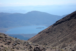
View of the Blue Lake -The track descends easily onto the scoria-dotted floor of Central Crater where the track to Oturere Hut leads off to the right. Across the wide crater there is a climb over the north rim and an excellent view back south of a large black lava flow that has spilled out of Red Crater. Over the rim, the track sidles past the wide, round Blue Lake and eases into the V of the Ketetahi Valley
Subscribe to:
Comments (Atom)


